

Geography revision covering physical processes that shape our world and...
 Geography3,770 views·Updated Jun 21, 2026·30 pages
GCSE AQA Geography Paper 1 Revision Notes (Case Studies Excluded)



1 / 10
1
of 10
Geography Revision - Physical Hazards Overview
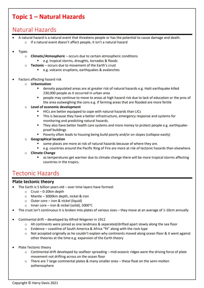
Natural hazards are natural events that threaten people or cause damage and death. If nobody's affected, it's not actually considered a hazard - it's just a natural event happening somewhere remote.
There are two main types you need to know. Climatic hazards happen due to atmospheric conditions and include tropical storms, droughts, and floods. Tectonic hazards occur when the Earth's crust moves, causing earthquakes, volcanic eruptions, and avalanches.
Several factors affect how risky these hazards are. Urbanisation means more people packed into smaller areas, so disasters affect more lives. Wealthy countries (HICs) cope much better than poorer ones (LICs) because they have better infrastructure, emergency services, and can afford earthquake-proof buildings. Your geographical location matters too - living near the Pacific Ring of Fire puts you at higher risk of tectonic hazards.
Key Point: Climate change is making tropical storms more frequent and intense as ocean temperatures rise, affecting countries in tropical regions more severely.
2
of 10
Tectonic Hazards and Plate Movement
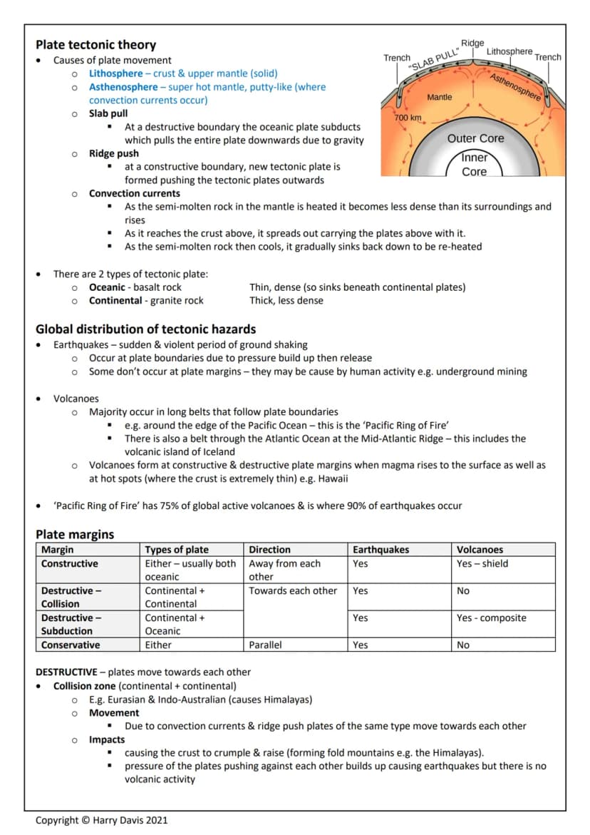
The Earth's structure consists of layers - the thin crust , the mantle (3000km deep), and the core with temperatures reaching 5000°C. The crust isn't one solid piece but broken into plates that move 1-10cm annually.
Alfred Wegener's continental drift theory from 1912 suggested continents were once joined and drifted apart. He had good evidence - South America and Africa's coastlines fit together like puzzle pieces, and they share similar rock types. However, nobody believed him initially because he couldn't explain how continents moved.
Plate tectonic theory eventually proved Wegener right. Plates float on the semi-molten asthenosphere and move due to three forces: slab pull (heavy oceanic plates dragging others down), ridge push (new plate formation pushing others away), and convection currents (hot rock rising and cool rock sinking).
There are two plate types: oceanic plates (thin, dense basalt that sinks) and continental plates (thick, lighter granite that floats). Understanding this helps explain why certain plate interactions create specific hazards.
Key Point: Most earthquakes (90%) and active volcanoes (75%) occur around the Pacific Ring of Fire, where multiple plates meet and interact.
3
of 10
Plate Boundaries and Their Effects
Different plate boundaries create different hazards depending on how plates move. Constructive margins occur where plates move apart, like Iceland on the Mid-Atlantic Ridge. Here, magma rises to create new oceanic crust, causing small earthquakes and shield volcanoes with runny lava and gentle slopes.
Destructive margins happen when plates collide. Collision zones involve two continental plates crumpling together, forming fold mountains like the Himalayas and causing violent earthquakes but no volcanoes. Subduction zones see dense oceanic plates diving under continental plates, creating deep ocean trenches, powerful earthquakes in the Benioff Zone, and composite volcanoes with steep sides and explosive eruptions.
Conservative margins involve plates sliding past each other, like the San Andreas Fault in California. Friction builds up pressure that releases as destructive, shallow earthquakes - but there's no volcanic activity since no magma rises.
Each boundary type creates distinct landscapes and hazard patterns. The type of plate involved (oceanic vs continental) and direction of movement determines whether you'll face earthquakes, volcanoes, or both.
Key Point: Composite volcanoes at subduction zones are far more dangerous than shield volcanoes because their thick, acidic lava creates violent, explosive eruptions.
4
of 10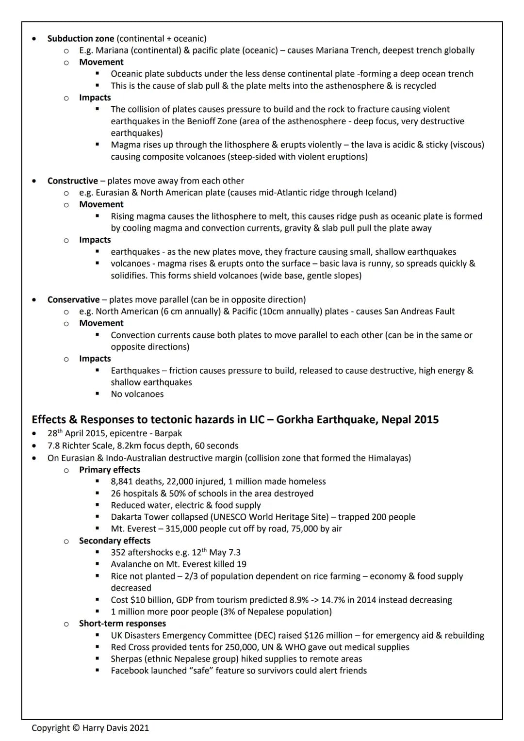
Comparing Earthquake Impacts: Nepal vs Italy
The 2015 Gorkha earthquake in Nepal (7.8 magnitude) killed 8,841 people and made 1 million homeless. This LIC struggled with the disaster - hospitals and schools collapsed, water and electricity failed, and UNESCO sites like Dakarta Tower trapped hundreds. Secondary effects included 352 aftershocks, deadly avalanches on Everest, and agricultural devastation that pushed 1 million more people into poverty.
Nepal's responses showed the challenges LICs face. International aid was crucial - the UK's DEC raised £126 million, while the Red Cross provided emergency shelters. However, long-term recovery was slow, with buildings taking much longer to rebuild than originally promised.
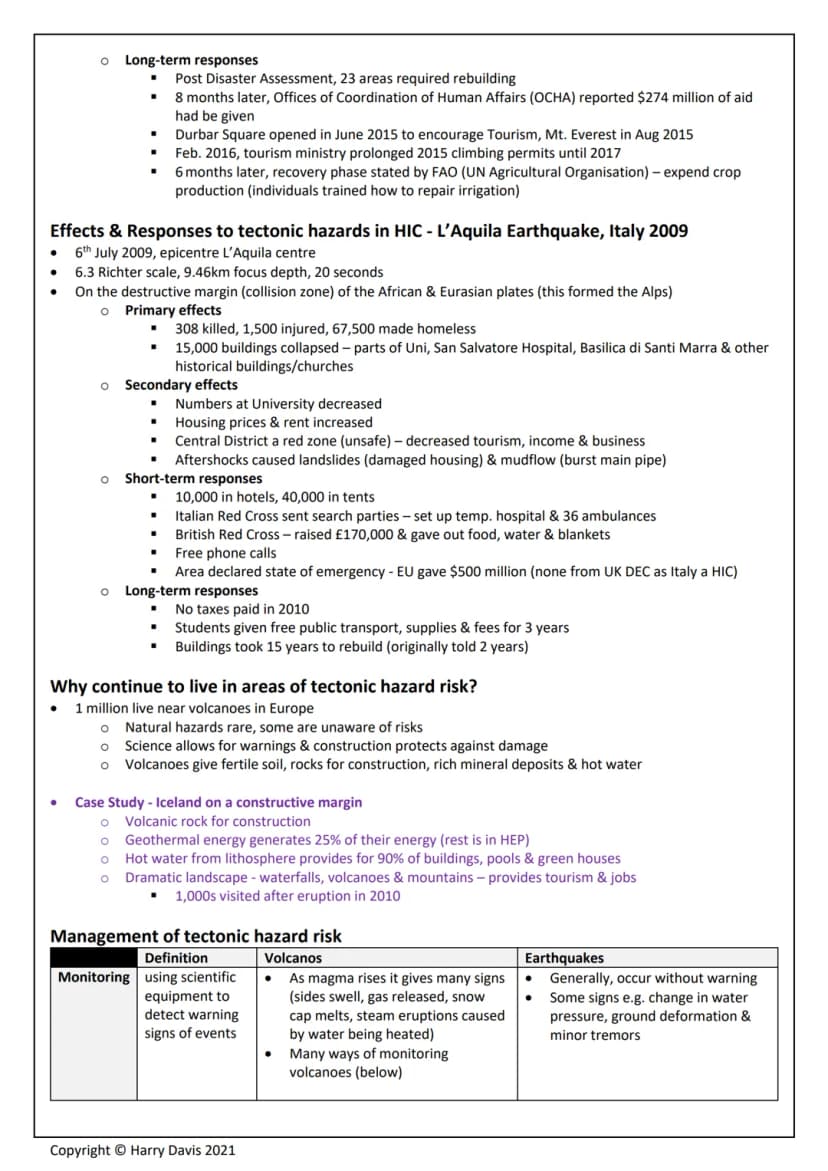
The 2009 L'Aquila earthquake in Italy (6.3 magnitude) killed 308 people despite being in a wealthy HIC. Better building standards and emergency responses meant far fewer casualties. Italy received €500 million from the EU and could provide immediate hotel accommodation for 10,000 people.
The contrast is striking - HICs have better monitoring systems, earthquake-resistant buildings, emergency services, and financial resources. However, even wealthy countries face challenges, as L'Aquila's rebuilding took 15 years instead of the promised 2.
Key Point: Economic development level dramatically affects earthquake impacts - Nepal's death toll was nearly 30 times higher than Italy's despite a similar-sized affected population.
5
of 10
Managing Tectonic Hazards
People continue living in hazardous areas because natural hazards are rare, many don't understand the risks, and these areas offer significant benefits. Volcanic regions provide fertile soil for farming, construction materials, mineral deposits, and geothermal energy. Iceland generates 25% of its electricity from geothermal sources and attracts thousands of tourists to see dramatic volcanic landscapes.
Monitoring uses scientific equipment to detect warning signs. Volcanoes give many clues before erupting - ground swelling, gas emissions, melting snow caps, and small earthquakes. Remote sensing satellites, seismographs, and gas monitors help scientists track these changes. Earthquakes are much harder to predict, though scientists can identify high-risk areas using historical data and plate boundary locations.
Protection strategies include building earthquake-resistant structures with reinforced concrete and flexible designs. Planning involves creating hazard maps, restricting building in dangerous areas, and preparing evacuation routes. Tsunami walls and building codes help reduce damage when disasters strike.
Iceland's 2010 volcanic eruption showed how effective monitoring can be - increased earthquake activity allowed scientists to make accurate predictions, giving people time to prepare and evacuate safely.
Key Point: While we can't prevent tectonic hazards, good monitoring, building standards, and emergency planning can dramatically reduce their impact on human life and property.
6
of 10
Global Weather Patterns
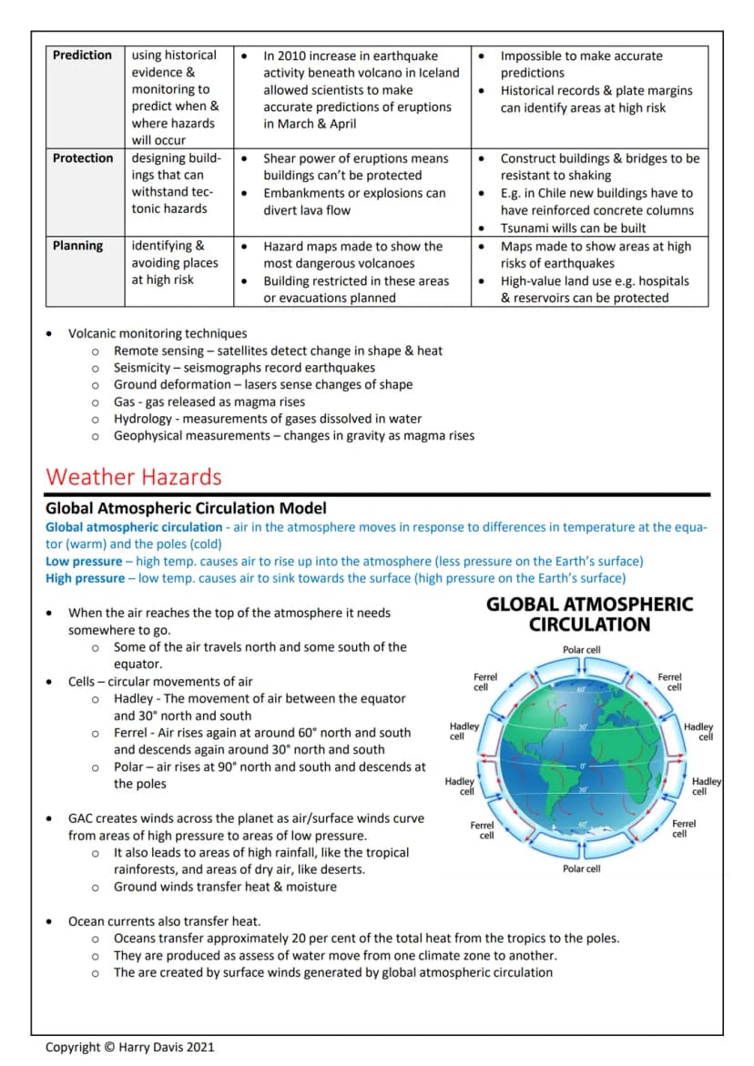
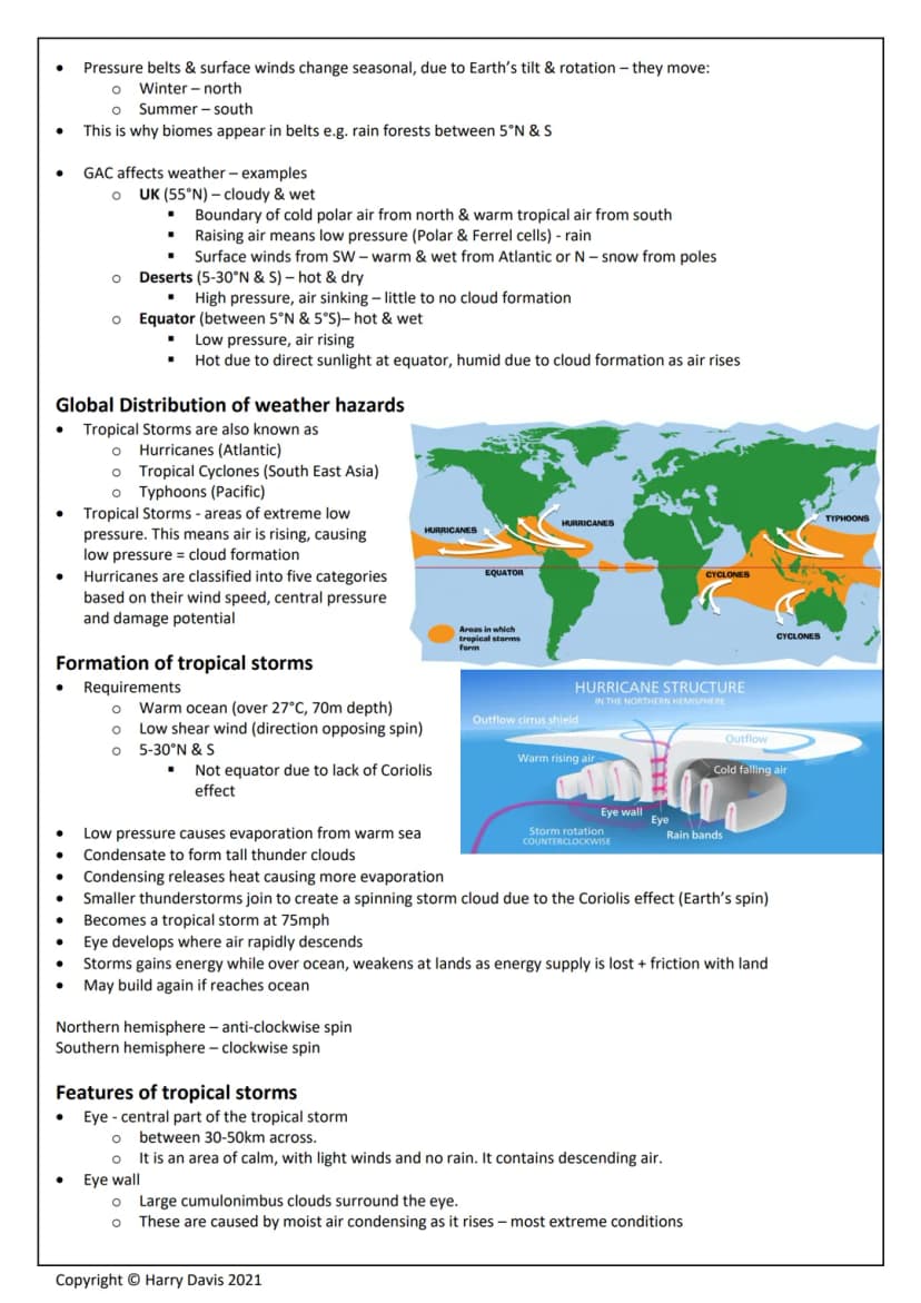
Global atmospheric circulation drives weather patterns worldwide by moving air between hot equatorial regions and cold polar areas. Low pressure occurs where warm air rises (creating clouds and rain), while high pressure happens where cool air sinks (creating clear, dry conditions).
The system creates three circulation cells in each hemisphere. Hadley cells move air between the equator and 30°N/S, Ferrel cells operate between 30° and 60°N/S, and Polar cells work between 60° and 90°N/S. This creates predictable weather patterns - deserts typically form around 30°N/S where air sinks, while equatorial regions stay hot and wet where air rises.
This explains why different regions have distinct climates. The UK sits at 55°N where cold polar air meets warm tropical air, creating our famously changeable, cloudy weather. Deserts occur in high-pressure zones with sinking air, while equatorial rainforests thrive where rising air creates constant precipitation.
Ocean currents also transfer about 20% of heat from tropics to poles, working alongside atmospheric circulation to balance global temperatures.
Key Point: Understanding circulation cells helps explain why rainforests, deserts, and temperate climates appear in predictable belts around the Earth.
7
of 10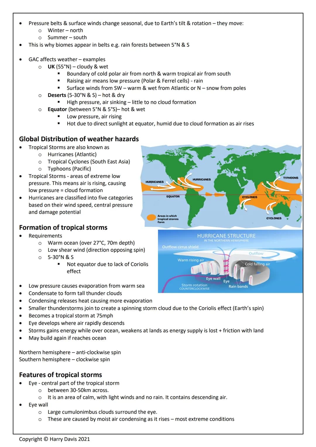
Tropical Storms Formation and Features
Tropical storms (hurricanes, cyclones, typhoons) are extreme low-pressure systems requiring specific conditions. They need ocean temperatures over 27°C to 70m depth, low wind shear, and must form between 5-30°N/S latitude - not at the equator where there's insufficient Coriolis effect to create spin.
Formation starts when warm ocean water evaporates rapidly due to low pressure. As water vapour condenses into towering thunderclouds, it releases heat energy that fuels more evaporation. Small thunderstorms merge and begin spinning due to Earth's rotation, becoming tropical storms at 75mph wind speeds.
The eye forms where air rapidly descends - this 30-50km wide zone stays calm with light winds and clear skies. The eye wall surrounding it contains the most extreme conditions with torrential rain, lightning, and the strongest winds. Storms gain energy over warm oceans but weaken over land due to friction and loss of their energy source.
Climate change is affecting tropical storms significantly. Rising sea surface temperatures mean storms can form in new areas and carry more energy. The last 25 years have seen 4% more atmospheric water vapour, making storms wetter and more destructive.
Key Point: As climate change raises ocean temperatures, tropical storms are becoming more intense and may affect areas that were previously safe, like southeastern Brazil in 2004.
8
of 10
Typhoon Haiyan Case Study
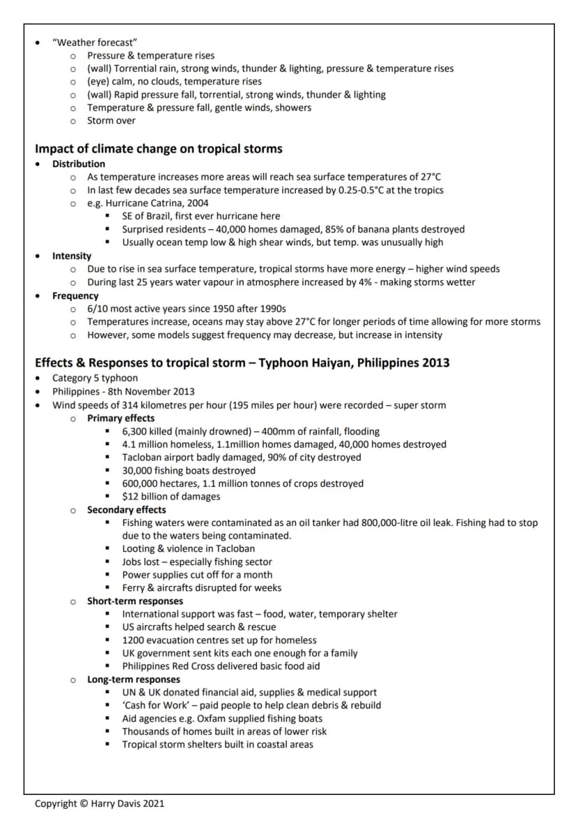
Typhoon Haiyan struck the Philippines in November 2013 as a Category 5 super storm with 314 km/h winds. This demonstrates how devastating tropical storms can be in LICs with dense populations and limited resources.
Primary effects were catastrophic - 6,300 deaths (mostly from drowning), 4.1 million people homeless, and 40,000 homes destroyed. Tacloban city was 90% destroyed, the airport badly damaged, and 600,000 hectares of crops wiped out. Total damages reached $12 billion.
Secondary effects included an 800,000-litre oil spill that contaminated fishing waters, widespread looting and violence, job losses, and disrupted transport for weeks. Power supplies were cut for a month, severely hampering recovery efforts.
International response was swift but highlighted the Philippines' vulnerability. The US provided search and rescue aircraft, 1,200 evacuation centres housed homeless families, and the UK sent family aid kits. Long-term responses included the UN's 'Cash for Work' programme, replacement fishing boats, and building homes in safer locations.
Key Point: Even with international aid, LICs like the Philippines struggle to cope with super storms due to poor infrastructure, dense populations in vulnerable areas, and limited emergency resources.
9
of 10
Reducing Tropical Storm Impacts
Protection strategies include building cyclone shelters with reinforced concrete, raised foundations, and strengthened windows and doors. Bangladesh has built 2,000 such shelters, while storm drains in urban areas and sea walls help manage flooding and storm surges.
Planning involves education and preparation rather than stopping people from living in coastal areas where fishing and tourism are vital. Hurricane Preparedness Week in the USA encourages families to create action plans and stock emergency supplies. Communities learn about predicted storm seasons and evacuation procedures.
Monitoring and prediction use satellite technology to track storm development and paths. However, prediction accuracy decreases over time as the potential track area widens. The North Atlantic uses two warning levels: Hurricane Watch (conditions possible) and Hurricane Warning (conditions expected, take shelter immediately).
Bangladesh shows how effective preparation saves lives. Their early warning systems use multiple languages and communication methods, including bicycles in rural areas. Deaths have fallen 100-fold over 40 years - from 500,000 in 1970 to 4,200 in 2007 - proving that LICs can significantly reduce casualties with proper planning.
Key Point: While LICs often lack expensive monitoring equipment, simple measures like early warning systems, community shelters, and public education can dramatically reduce tropical storm casualties.
10
of 10
UK Weather Hazards
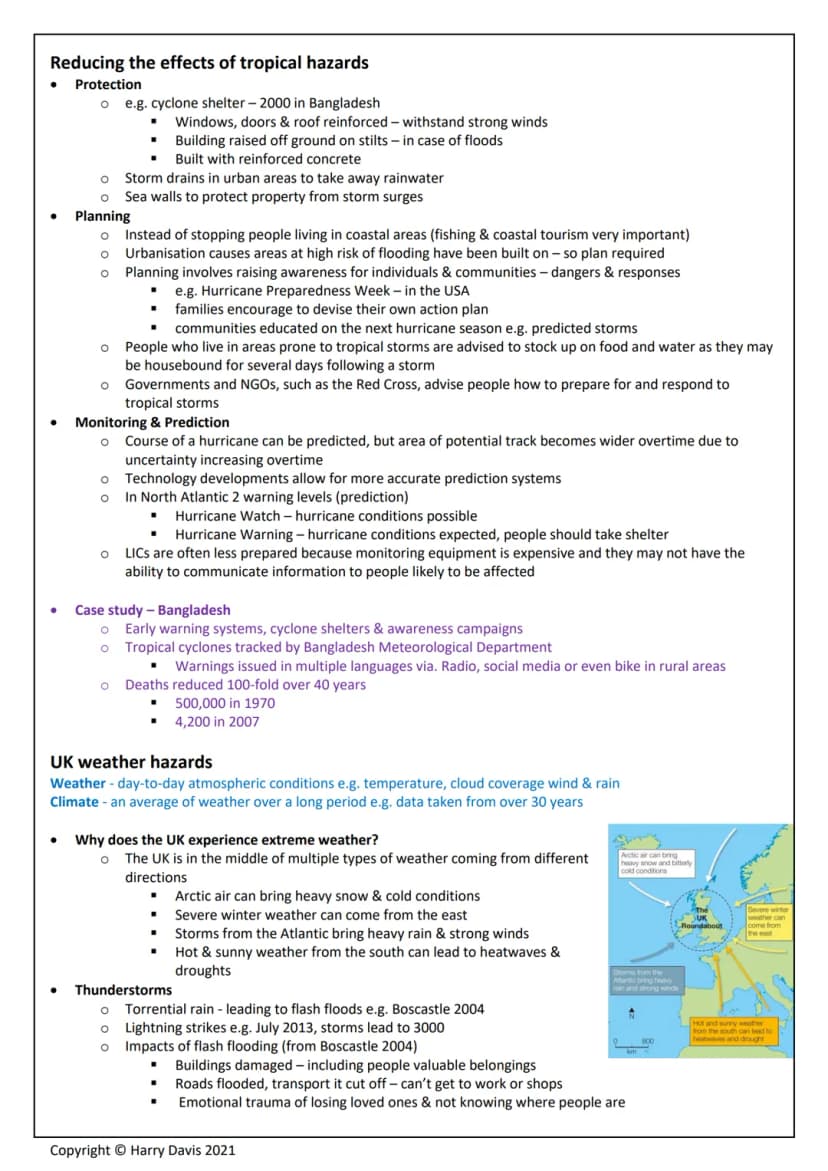
The UK experiences extreme weather because it sits between different air masses - cold polar air from the north and warm tropical air from the south. This creates our changeable climate and various weather hazards.
Thunderstorms bring torrential rain causing flash floods like Boscastle 2004, plus lightning strikes and property damage. Droughts and extreme heat can dry up rivers and reservoirs - the 2003 European heatwave killed 20,000 people. Strong winds from Atlantic storm remnants disrupt transport and power supplies. Prolonged rainfall causes river flooding, especially in winter with snowmelt.
The 2014 Somerset Levels floods show how multiple factors create disasters. The wettest January on record (350mm rain, 100mm above average) combined with high tides preventing river drainage and 20 years without river dredging. This caused widespread flooding across 14,000 hectares of farmland.
Impacts included 600 flooded homes, 16 evacuated farms, cut power supplies, and £10 million in damages. Management responses included a £20 million Flood Action Plan with river dredging, raised riverbanks, new pumping stations, and improved flood defences.
Key Point: UK weather hazards may seem minor compared to tropical storms or earthquakes, but they still cause significant economic damage and disruption to daily life, requiring careful management strategies.
We thought you’d never ask...
What is the Knowunity AI companion?
Our AI companion is specifically built for the needs of students. Based on the millions of content pieces we have on the platform we can provide truly meaningful and relevant answers to students. But its not only about answers, the companion is even more about guiding students through their daily learning challenges, with personalised study plans, quizzes or content pieces in the chat and 100% personalisation based on the students skills and developments.
Where can I download the Knowunity app?
You can download the app in the Google Play Store and in the Apple App Store.
Is Knowunity really free of charge?
That's right! Enjoy free access to study content, connect with fellow students, and get instant help – all at your fingertips.
Similar Content
Most popular content: Natural Hazards
9GeographyTyphoon Haiyan Overview
Explore the devastating impact of Typhoon Haiyan (2013) through its formation, primary and secondary effects, and both immediate and long-term responses. This case study highlights the catastrophic consequences for the Philippines, including loss of life, displacement, and recovery efforts. Ideal for students studying natural disasters and their management.
111,77652
GeographyGeography Case Studies Overview
Explore essential case studies for AQA Geography GCSE Paper 1, covering topics such as desertification, flood management, coastal landscapes, and natural hazards like the Haiti earthquake and Typhoon Haiyan. This summary provides insights into key concepts including overgrazing, soil degradation, and effective management strategies. Ideal for students preparing for their exams.
112,51934
GeographyGeography of Natural Hazards
Explore the complexities of natural hazards in this comprehensive study note. Covering key topics such as tectonic hazards, volcanic activity, tropical storms, and case studies like Typhoon Haiyan and the Haiti earthquake, this resource provides essential insights into risk management and the impacts of disasters. Ideal for A Level Geography students seeking to deepen their understanding of environmental dynamics and hazard responses.
122,934157
GeographyNepal & Chile Earthquake Analysis
Explore the devastating impacts and responses to the 2015 Nepal earthquake and the 2010 Chile earthquake. This detailed case study covers primary and secondary effects, immediate and long-term responses, and recovery efforts. Ideal for geography students studying natural disasters and earthquake case studies.
111,69252
GeographyHaiti Earthquake 2010 Overview
Explore the devastating impact of the 2010 Haiti earthquake, a significant case study in natural disasters affecting low-income countries (LICs). This summary covers key facts, primary and secondary effects, and both short-term and long-term responses, including international aid efforts and recovery strategies.
113318
GeographyTectonic Hazards Analysis
Explore in-depth case studies of tectonic hazards and processes relevant to A Level Geography. This resource covers key concepts such as earthquake dynamics, volcanic activity, and their impacts on human and physical environments. Ideal for Edexcel students preparing for exams.
121,13539
GeographyNatural Disasters Case Studies
Explore detailed case studies on significant natural disasters including the Nepal Earthquake, Japan Earthquake, Typhoon Haiyan, and Hurricane Katrina. This resource covers primary and secondary impacts, immediate and long-term responses, and urban strategies in India. Ideal for geography students seeking to understand the complexities of natural hazards and their socio-economic effects.
111,60198
GeographyGeography Hazards Overview
Comprehensive study notes covering key concepts in A Level Geography Hazards, including tectonic processes, volcanic activity, and case studies on earthquakes and tropical cyclones. Ideal for AQA A Level Geography students seeking to understand natural hazards and their impacts.
1273713
GeographyUrban Challenges & Natural Hazards
Explore key case studies on urbanization and natural hazards, including the Mumbai megacity, the Haiti and Japan earthquakes, and tropical storms like Katrina and Nargis. This mindmap provides a comprehensive overview of human impacts on the environment and urban issues, essential for understanding geography concepts in Edexcel B.
1196110
Most popular content in Geography
9U
GeographyUrbanisation - AQA GCSE Geography
Some questions on key knowledge from the Urbanisation topic in GCSE Geography
98070
T
Geographytopic one- hazards flashcards set 1
Explore the fascinating world of geography with these flashcards covering diverse topics like continents, landmarks, and natural wonders. Enhance your knowledge and ace your exams!
114760
E
GeographyExploring Natural Hazards: Causes and Effects
Discover the primary causes and common effects of natural hazards such as tsunamis, volcanic eruptions, hurricanes, wildfires, droughts, landslides, and more!
113230
I
GeographyIntroduction to Natural Hazard Types
Identify the differences between geological and meteorological hazards and understand the factors affecting hazard risk.
S32880
GeographyGeography Hazards & Landscapes
Explore key concepts in AQA Geography, covering rivers, coasts, natural hazards, and ecosystems. This summary highlights essential topics such as river processes, coastal management, desertification, and case studies on earthquakes and tropical storms. Ideal for exam preparation and understanding geographical systems.
103,064117
P
GeographyPaper 1? Down what else
Explore the fascinating world of geography with these flashcards covering diverse topics like continents, landmarks, and natural wonders. Enhance your knowledge and ace your exams!
114782
I
GeographyIntroduction to Global Urbanisation Concepts
Define urbanisation, explore rural-to-urban migration, and identify the push and pull factors driving global city growth.
112210
GeographyRio de Janeiro case study
AQA geography gcse
1095526
GeographyOCR B Geography Case Studies
Comprehensive revision notes covering key OCR B Geography case studies, including topics on climate change, urbanization, food security, and natural hazards. This resource is designed to aid students in understanding geographical concepts and preparing for exams effectively. Key case studies include Typhoon Haiyan, urban growth in Rio, and sustainable development practices in Tanzania.
102,00537
Most popular content
9 Sociology
Sociology of Education Overview
Explore comprehensive A-Level Sociology notes on the education system, covering key theories, policies, and sociological perspectives. This resource includes insights on marketisation, gender roles, cultural deprivation, and educational inequalities, providing a thorough understanding of how education shapes social stratification and individual achievement. Ideal for exam preparation and in-depth study.
12102,8693,040
SociologySociology of Families: Comprehensive Revision
Dive into an extensive overview of family dynamics, perspectives, and patterns in sociology. This resource covers key concepts such as family diversity, gender roles, marriage, and the impact of social policies on family structures. Perfect for A-Level Sociology students preparing for Paper 2.
1273,6612,307
CriminologyCriminology: Crime & Punishment Overview
Comprehensive mindmaps covering key concepts in the Crime and Punishment topic for WJEC Criminology Unit 4. This resource includes detailed insights into the Criminal Justice System, crime prevention strategies, sentencing models, and the roles of various agencies. Ideal for A-Level revision, ensuring you grasp essential theories and legislative processes to excel in your exams.
1254,8691,059
SociologyComprehensive Crime & Deviance Overview
Explore an extensive revision of crime and deviance topics, including theories, types of crime, and the impact of media. This resource covers key concepts such as Marxism, functionalism, gender and crime, and the influence of globalization on criminal behavior. Ideal for students seeking a thorough understanding of criminology and its various theories. Type: Full Topic Revision.
1251,6541,399
C
 Biology
Cell Biology and Cell structure
cell structures
93,2470
 English Literature
An Inspector Calls: Character Insights
Explore in-depth analysis and key quotes for characters in J.B. Priestley's 'An Inspector Calls'. This resource covers Gerald Croft, Inspector Goole, Sheila Birling, Mrs. Birling, Eric Birling, and Eva Smith, focusing on themes of class, gender roles, and social responsibility. Ideal for students aiming for Grade 8 and above.
1025,429907
CriminologyWJEC Unit 4 Criminology
Criminology unit 4 detailed revision note
127,151125
CriminologyCriminology Theories Overview
Explore key criminology theories and their implications on crime and deviance. This comprehensive summary covers biological, psychological, and sociological perspectives, including labelling theory, right realism, and the impact of social campaigns on policy development. Ideal for A-Level criminology students seeking to understand the complexities of criminal behaviour and the factors influencing crime prevention strategies.
129,760210
English LiteratureRomeo and Juliet: Key themes
Key Romeo and Juliet themes and analysed quotes
106,708198
Can't find what you're looking for? Explore other subjects.
Students love us — and so will you.
4.6/5App Store
4.7/5Google Play
The app is very easy to use and well designed. I have found everything I was looking for so far and have been able to learn a lot from the presentations! I will definitely use the app for a class assignment! And of course it also helps a lot as an inspiration.
Stefan SiOS user
This app is really great. There are so many study notes and help [...]. My problem subject is French, for example, and the app has so many options for help. Thanks to this app, I have improved my French. I would recommend it to anyone.
Samantha KlichAndroid user
Wow, I am really amazed. I just tried the app because I've seen it advertised many times and was absolutely stunned. This app is THE HELP you want for school and above all, it offers so many things, such as workouts and fact sheets, which have been VERY helpful to me personally.
AnnaiOS user
Geography3,770 views·Updated Jun 21, 2026·30 pagesGCSE AQA Geography Paper 1 Revision Notes (Case Studies Excluded)
Geography revision covering physical processes that shape our world and affect human life. This guide breaks down natural hazards, tectonic activity, and weather patterns - essential topics that explain everything from devastating earthquakes to the storms that hit the UK.
1
of 10
Sign up to see the content. It's free!
- Access to all documents
- Improve your grades
- Join milions of students
Geography Revision - Physical Hazards Overview
Natural hazards are natural events that threaten people or cause damage and death. If nobody's affected, it's not actually considered a hazard - it's just a natural event happening somewhere remote.
There are two main types you need to know. Climatic hazards happen due to atmospheric conditions and include tropical storms, droughts, and floods. Tectonic hazards occur when the Earth's crust moves, causing earthquakes, volcanic eruptions, and avalanches.
Several factors affect how risky these hazards are. Urbanisation means more people packed into smaller areas, so disasters affect more lives. Wealthy countries (HICs) cope much better than poorer ones (LICs) because they have better infrastructure, emergency services, and can afford earthquake-proof buildings. Your geographical location matters too - living near the Pacific Ring of Fire puts you at higher risk of tectonic hazards.
Key Point: Climate change is making tropical storms more frequent and intense as ocean temperatures rise, affecting countries in tropical regions more severely.
2
of 10Sign up to see the content. It's free!
- Access to all documents
- Improve your grades
- Join milions of students
Tectonic Hazards and Plate Movement
The Earth's structure consists of layers - the thin crust , the mantle (3000km deep), and the core with temperatures reaching 5000°C. The crust isn't one solid piece but broken into plates that move 1-10cm annually.
Alfred Wegener's continental drift theory from 1912 suggested continents were once joined and drifted apart. He had good evidence - South America and Africa's coastlines fit together like puzzle pieces, and they share similar rock types. However, nobody believed him initially because he couldn't explain how continents moved.
Plate tectonic theory eventually proved Wegener right. Plates float on the semi-molten asthenosphere and move due to three forces: slab pull (heavy oceanic plates dragging others down), ridge push (new plate formation pushing others away), and convection currents (hot rock rising and cool rock sinking).
There are two plate types: oceanic plates (thin, dense basalt that sinks) and continental plates (thick, lighter granite that floats). Understanding this helps explain why certain plate interactions create specific hazards.
Key Point: Most earthquakes (90%) and active volcanoes (75%) occur around the Pacific Ring of Fire, where multiple plates meet and interact.
3
of 10Sign up to see the content. It's free!
- Access to all documents
- Improve your grades
- Join milions of students
Plate Boundaries and Their Effects
Different plate boundaries create different hazards depending on how plates move. Constructive margins occur where plates move apart, like Iceland on the Mid-Atlantic Ridge. Here, magma rises to create new oceanic crust, causing small earthquakes and shield volcanoes with runny lava and gentle slopes.
Destructive margins happen when plates collide. Collision zones involve two continental plates crumpling together, forming fold mountains like the Himalayas and causing violent earthquakes but no volcanoes. Subduction zones see dense oceanic plates diving under continental plates, creating deep ocean trenches, powerful earthquakes in the Benioff Zone, and composite volcanoes with steep sides and explosive eruptions.
Conservative margins involve plates sliding past each other, like the San Andreas Fault in California. Friction builds up pressure that releases as destructive, shallow earthquakes - but there's no volcanic activity since no magma rises.
Each boundary type creates distinct landscapes and hazard patterns. The type of plate involved (oceanic vs continental) and direction of movement determines whether you'll face earthquakes, volcanoes, or both.
Key Point: Composite volcanoes at subduction zones are far more dangerous than shield volcanoes because their thick, acidic lava creates violent, explosive eruptions.
4
of 10Sign up to see the content. It's free!
- Access to all documents
- Improve your grades
- Join milions of students
Comparing Earthquake Impacts: Nepal vs Italy
The 2015 Gorkha earthquake in Nepal (7.8 magnitude) killed 8,841 people and made 1 million homeless. This LIC struggled with the disaster - hospitals and schools collapsed, water and electricity failed, and UNESCO sites like Dakarta Tower trapped hundreds. Secondary effects included 352 aftershocks, deadly avalanches on Everest, and agricultural devastation that pushed 1 million more people into poverty.
Nepal's responses showed the challenges LICs face. International aid was crucial - the UK's DEC raised £126 million, while the Red Cross provided emergency shelters. However, long-term recovery was slow, with buildings taking much longer to rebuild than originally promised.
The 2009 L'Aquila earthquake in Italy (6.3 magnitude) killed 308 people despite being in a wealthy HIC. Better building standards and emergency responses meant far fewer casualties. Italy received €500 million from the EU and could provide immediate hotel accommodation for 10,000 people.
The contrast is striking - HICs have better monitoring systems, earthquake-resistant buildings, emergency services, and financial resources. However, even wealthy countries face challenges, as L'Aquila's rebuilding took 15 years instead of the promised 2.
Key Point: Economic development level dramatically affects earthquake impacts - Nepal's death toll was nearly 30 times higher than Italy's despite a similar-sized affected population.
5
of 10Sign up to see the content. It's free!
- Access to all documents
- Improve your grades
- Join milions of students
Managing Tectonic Hazards
People continue living in hazardous areas because natural hazards are rare, many don't understand the risks, and these areas offer significant benefits. Volcanic regions provide fertile soil for farming, construction materials, mineral deposits, and geothermal energy. Iceland generates 25% of its electricity from geothermal sources and attracts thousands of tourists to see dramatic volcanic landscapes.
Monitoring uses scientific equipment to detect warning signs. Volcanoes give many clues before erupting - ground swelling, gas emissions, melting snow caps, and small earthquakes. Remote sensing satellites, seismographs, and gas monitors help scientists track these changes. Earthquakes are much harder to predict, though scientists can identify high-risk areas using historical data and plate boundary locations.
Protection strategies include building earthquake-resistant structures with reinforced concrete and flexible designs. Planning involves creating hazard maps, restricting building in dangerous areas, and preparing evacuation routes. Tsunami walls and building codes help reduce damage when disasters strike.
Iceland's 2010 volcanic eruption showed how effective monitoring can be - increased earthquake activity allowed scientists to make accurate predictions, giving people time to prepare and evacuate safely.
Key Point: While we can't prevent tectonic hazards, good monitoring, building standards, and emergency planning can dramatically reduce their impact on human life and property.
6
of 10Sign up to see the content. It's free!
- Access to all documents
- Improve your grades
- Join milions of students
Global Weather Patterns
Global atmospheric circulation drives weather patterns worldwide by moving air between hot equatorial regions and cold polar areas. Low pressure occurs where warm air rises (creating clouds and rain), while high pressure happens where cool air sinks (creating clear, dry conditions).
The system creates three circulation cells in each hemisphere. Hadley cells move air between the equator and 30°N/S, Ferrel cells operate between 30° and 60°N/S, and Polar cells work between 60° and 90°N/S. This creates predictable weather patterns - deserts typically form around 30°N/S where air sinks, while equatorial regions stay hot and wet where air rises.
This explains why different regions have distinct climates. The UK sits at 55°N where cold polar air meets warm tropical air, creating our famously changeable, cloudy weather. Deserts occur in high-pressure zones with sinking air, while equatorial rainforests thrive where rising air creates constant precipitation.
Ocean currents also transfer about 20% of heat from tropics to poles, working alongside atmospheric circulation to balance global temperatures.
Key Point: Understanding circulation cells helps explain why rainforests, deserts, and temperate climates appear in predictable belts around the Earth.
7
of 10Sign up to see the content. It's free!
- Access to all documents
- Improve your grades
- Join milions of students
Tropical Storms Formation and Features
Tropical storms (hurricanes, cyclones, typhoons) are extreme low-pressure systems requiring specific conditions. They need ocean temperatures over 27°C to 70m depth, low wind shear, and must form between 5-30°N/S latitude - not at the equator where there's insufficient Coriolis effect to create spin.
Formation starts when warm ocean water evaporates rapidly due to low pressure. As water vapour condenses into towering thunderclouds, it releases heat energy that fuels more evaporation. Small thunderstorms merge and begin spinning due to Earth's rotation, becoming tropical storms at 75mph wind speeds.
The eye forms where air rapidly descends - this 30-50km wide zone stays calm with light winds and clear skies. The eye wall surrounding it contains the most extreme conditions with torrential rain, lightning, and the strongest winds. Storms gain energy over warm oceans but weaken over land due to friction and loss of their energy source.
Climate change is affecting tropical storms significantly. Rising sea surface temperatures mean storms can form in new areas and carry more energy. The last 25 years have seen 4% more atmospheric water vapour, making storms wetter and more destructive.
Key Point: As climate change raises ocean temperatures, tropical storms are becoming more intense and may affect areas that were previously safe, like southeastern Brazil in 2004.
8
of 10Sign up to see the content. It's free!
- Access to all documents
- Improve your grades
- Join milions of students
Typhoon Haiyan Case Study
Typhoon Haiyan struck the Philippines in November 2013 as a Category 5 super storm with 314 km/h winds. This demonstrates how devastating tropical storms can be in LICs with dense populations and limited resources.
Primary effects were catastrophic - 6,300 deaths (mostly from drowning), 4.1 million people homeless, and 40,000 homes destroyed. Tacloban city was 90% destroyed, the airport badly damaged, and 600,000 hectares of crops wiped out. Total damages reached $12 billion.
Secondary effects included an 800,000-litre oil spill that contaminated fishing waters, widespread looting and violence, job losses, and disrupted transport for weeks. Power supplies were cut for a month, severely hampering recovery efforts.
International response was swift but highlighted the Philippines' vulnerability. The US provided search and rescue aircraft, 1,200 evacuation centres housed homeless families, and the UK sent family aid kits. Long-term responses included the UN's 'Cash for Work' programme, replacement fishing boats, and building homes in safer locations.
Key Point: Even with international aid, LICs like the Philippines struggle to cope with super storms due to poor infrastructure, dense populations in vulnerable areas, and limited emergency resources.
9
of 10Sign up to see the content. It's free!
- Access to all documents
- Improve your grades
- Join milions of students
Reducing Tropical Storm Impacts
Protection strategies include building cyclone shelters with reinforced concrete, raised foundations, and strengthened windows and doors. Bangladesh has built 2,000 such shelters, while storm drains in urban areas and sea walls help manage flooding and storm surges.
Planning involves education and preparation rather than stopping people from living in coastal areas where fishing and tourism are vital. Hurricane Preparedness Week in the USA encourages families to create action plans and stock emergency supplies. Communities learn about predicted storm seasons and evacuation procedures.
Monitoring and prediction use satellite technology to track storm development and paths. However, prediction accuracy decreases over time as the potential track area widens. The North Atlantic uses two warning levels: Hurricane Watch (conditions possible) and Hurricane Warning (conditions expected, take shelter immediately).
Bangladesh shows how effective preparation saves lives. Their early warning systems use multiple languages and communication methods, including bicycles in rural areas. Deaths have fallen 100-fold over 40 years - from 500,000 in 1970 to 4,200 in 2007 - proving that LICs can significantly reduce casualties with proper planning.
Key Point: While LICs often lack expensive monitoring equipment, simple measures like early warning systems, community shelters, and public education can dramatically reduce tropical storm casualties.
10
of 10Sign up to see the content. It's free!
- Access to all documents
- Improve your grades
- Join milions of students
UK Weather Hazards
The UK experiences extreme weather because it sits between different air masses - cold polar air from the north and warm tropical air from the south. This creates our changeable climate and various weather hazards.
Thunderstorms bring torrential rain causing flash floods like Boscastle 2004, plus lightning strikes and property damage. Droughts and extreme heat can dry up rivers and reservoirs - the 2003 European heatwave killed 20,000 people. Strong winds from Atlantic storm remnants disrupt transport and power supplies. Prolonged rainfall causes river flooding, especially in winter with snowmelt.
The 2014 Somerset Levels floods show how multiple factors create disasters. The wettest January on record (350mm rain, 100mm above average) combined with high tides preventing river drainage and 20 years without river dredging. This caused widespread flooding across 14,000 hectares of farmland.
Impacts included 600 flooded homes, 16 evacuated farms, cut power supplies, and £10 million in damages. Management responses included a £20 million Flood Action Plan with river dredging, raised riverbanks, new pumping stations, and improved flood defences.
Key Point: UK weather hazards may seem minor compared to tropical storms or earthquakes, but they still cause significant economic damage and disruption to daily life, requiring careful management strategies.
We thought you’d never ask...
What is the Knowunity AI companion?
Our AI companion is specifically built for the needs of students. Based on the millions of content pieces we have on the platform we can provide truly meaningful and relevant answers to students. But its not only about answers, the companion is even more about guiding students through their daily learning challenges, with personalised study plans, quizzes or content pieces in the chat and 100% personalisation based on the students skills and developments.
Where can I download the Knowunity app?
You can download the app in the Google Play Store and in the Apple App Store.
Is Knowunity really free of charge?
That's right! Enjoy free access to study content, connect with fellow students, and get instant help – all at your fingertips.
Similar Content
Most popular content: Natural Hazards
9GeographyTyphoon Haiyan Overview
Explore the devastating impact of Typhoon Haiyan (2013) through its formation, primary and secondary effects, and both immediate and long-term responses. This case study highlights the catastrophic consequences for the Philippines, including loss of life, displacement, and recovery efforts. Ideal for students studying natural disasters and their management.
111,77652
GeographyGeography Case Studies Overview
Explore essential case studies for AQA Geography GCSE Paper 1, covering topics such as desertification, flood management, coastal landscapes, and natural hazards like the Haiti earthquake and Typhoon Haiyan. This summary provides insights into key concepts including overgrazing, soil degradation, and effective management strategies. Ideal for students preparing for their exams.
112,51934
GeographyGeography of Natural Hazards
Explore the complexities of natural hazards in this comprehensive study note. Covering key topics such as tectonic hazards, volcanic activity, tropical storms, and case studies like Typhoon Haiyan and the Haiti earthquake, this resource provides essential insights into risk management and the impacts of disasters. Ideal for A Level Geography students seeking to deepen their understanding of environmental dynamics and hazard responses.
122,934157
GeographyNepal & Chile Earthquake Analysis
Explore the devastating impacts and responses to the 2015 Nepal earthquake and the 2010 Chile earthquake. This detailed case study covers primary and secondary effects, immediate and long-term responses, and recovery efforts. Ideal for geography students studying natural disasters and earthquake case studies.
111,69252
GeographyHaiti Earthquake 2010 Overview
Explore the devastating impact of the 2010 Haiti earthquake, a significant case study in natural disasters affecting low-income countries (LICs). This summary covers key facts, primary and secondary effects, and both short-term and long-term responses, including international aid efforts and recovery strategies.
113318
GeographyTectonic Hazards Analysis
Explore in-depth case studies of tectonic hazards and processes relevant to A Level Geography. This resource covers key concepts such as earthquake dynamics, volcanic activity, and their impacts on human and physical environments. Ideal for Edexcel students preparing for exams.
121,13539
GeographyNatural Disasters Case Studies
Explore detailed case studies on significant natural disasters including the Nepal Earthquake, Japan Earthquake, Typhoon Haiyan, and Hurricane Katrina. This resource covers primary and secondary impacts, immediate and long-term responses, and urban strategies in India. Ideal for geography students seeking to understand the complexities of natural hazards and their socio-economic effects.
111,60198
GeographyGeography Hazards Overview
Comprehensive study notes covering key concepts in A Level Geography Hazards, including tectonic processes, volcanic activity, and case studies on earthquakes and tropical cyclones. Ideal for AQA A Level Geography students seeking to understand natural hazards and their impacts.
1273713
GeographyUrban Challenges & Natural Hazards
Explore key case studies on urbanization and natural hazards, including the Mumbai megacity, the Haiti and Japan earthquakes, and tropical storms like Katrina and Nargis. This mindmap provides a comprehensive overview of human impacts on the environment and urban issues, essential for understanding geography concepts in Edexcel B.
1196110
Most popular content in Geography
9U
GeographyUrbanisation - AQA GCSE Geography
Some questions on key knowledge from the Urbanisation topic in GCSE Geography
98070
T
Geographytopic one- hazards flashcards set 1
Explore the fascinating world of geography with these flashcards covering diverse topics like continents, landmarks, and natural wonders. Enhance your knowledge and ace your exams!
114760
E
GeographyExploring Natural Hazards: Causes and Effects
Discover the primary causes and common effects of natural hazards such as tsunamis, volcanic eruptions, hurricanes, wildfires, droughts, landslides, and more!
113230
I
GeographyIntroduction to Natural Hazard Types
Identify the differences between geological and meteorological hazards and understand the factors affecting hazard risk.
S32880
GeographyGeography Hazards & Landscapes
Explore key concepts in AQA Geography, covering rivers, coasts, natural hazards, and ecosystems. This summary highlights essential topics such as river processes, coastal management, desertification, and case studies on earthquakes and tropical storms. Ideal for exam preparation and understanding geographical systems.
103,064117
P
GeographyPaper 1? Down what else
Explore the fascinating world of geography with these flashcards covering diverse topics like continents, landmarks, and natural wonders. Enhance your knowledge and ace your exams!
114782
I
GeographyIntroduction to Global Urbanisation Concepts
Define urbanisation, explore rural-to-urban migration, and identify the push and pull factors driving global city growth.
112210
GeographyRio de Janeiro case study
AQA geography gcse
1095526
GeographyOCR B Geography Case Studies
Comprehensive revision notes covering key OCR B Geography case studies, including topics on climate change, urbanization, food security, and natural hazards. This resource is designed to aid students in understanding geographical concepts and preparing for exams effectively. Key case studies include Typhoon Haiyan, urban growth in Rio, and sustainable development practices in Tanzania.
102,00537
Most popular content
9SociologySociology of Education Overview
Explore comprehensive A-Level Sociology notes on the education system, covering key theories, policies, and sociological perspectives. This resource includes insights on marketisation, gender roles, cultural deprivation, and educational inequalities, providing a thorough understanding of how education shapes social stratification and individual achievement. Ideal for exam preparation and in-depth study.
12102,8693,040
SociologySociology of Families: Comprehensive Revision
Dive into an extensive overview of family dynamics, perspectives, and patterns in sociology. This resource covers key concepts such as family diversity, gender roles, marriage, and the impact of social policies on family structures. Perfect for A-Level Sociology students preparing for Paper 2.
1273,6612,307
CriminologyCriminology: Crime & Punishment Overview
Comprehensive mindmaps covering key concepts in the Crime and Punishment topic for WJEC Criminology Unit 4. This resource includes detailed insights into the Criminal Justice System, crime prevention strategies, sentencing models, and the roles of various agencies. Ideal for A-Level revision, ensuring you grasp essential theories and legislative processes to excel in your exams.
1254,8691,059
SociologyComprehensive Crime & Deviance Overview
Explore an extensive revision of crime and deviance topics, including theories, types of crime, and the impact of media. This resource covers key concepts such as Marxism, functionalism, gender and crime, and the influence of globalization on criminal behavior. Ideal for students seeking a thorough understanding of criminology and its various theories. Type: Full Topic Revision.
1251,6541,399
C
BiologyCell Biology and Cell structure
cell structures
93,2470
English LiteratureAn Inspector Calls: Character Insights
Explore in-depth analysis and key quotes for characters in J.B. Priestley's 'An Inspector Calls'. This resource covers Gerald Croft, Inspector Goole, Sheila Birling, Mrs. Birling, Eric Birling, and Eva Smith, focusing on themes of class, gender roles, and social responsibility. Ideal for students aiming for Grade 8 and above.
1025,429907
CriminologyWJEC Unit 4 Criminology
Criminology unit 4 detailed revision note
127,151125
CriminologyCriminology Theories Overview
Explore key criminology theories and their implications on crime and deviance. This comprehensive summary covers biological, psychological, and sociological perspectives, including labelling theory, right realism, and the impact of social campaigns on policy development. Ideal for A-Level criminology students seeking to understand the complexities of criminal behaviour and the factors influencing crime prevention strategies.
129,760210
English LiteratureRomeo and Juliet: Key themes
Key Romeo and Juliet themes and analysed quotes
106,708198
Can't find what you're looking for? Explore other subjects.
Students love us — and so will you.
4.6/5App Store
4.7/5Google Play
The app is very easy to use and well designed. I have found everything I was looking for so far and have been able to learn a lot from the presentations! I will definitely use the app for a class assignment! And of course it also helps a lot as an inspiration.
Stefan SiOS user
This app is really great. There are so many study notes and help [...]. My problem subject is French, for example, and the app has so many options for help. Thanks to this app, I have improved my French. I would recommend it to anyone.
Samantha KlichAndroid user
Wow, I am really amazed. I just tried the app because I've seen it advertised many times and was absolutely stunned. This app is THE HELP you want for school and above all, it offers so many things, such as workouts and fact sheets, which have been VERY helpful to me personally.
AnnaiOS user